
 |
International Mountaineering and Climbing Federation |
 |
Escuela Española de Alta Montaña |
| Club Andino Boliviano | |
 |
Instituto Boliviano de Biología de la altura
|
 |
Rest in Carpathian
|
MOUNTAINEERING
Huayna Potosí | Charquini | Pequeño Alpamayo | Condoriri | Illimani | Sajama | Parinacota | Pomerata | Mururata | Ancohuma | Illampu
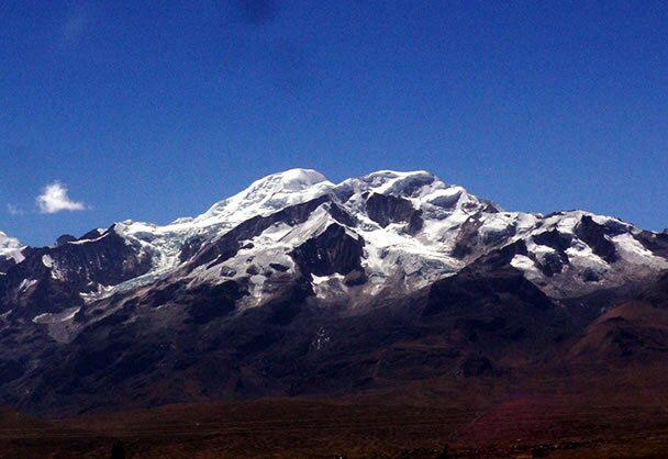
Huayna Potosí 6088 m.s.n.m.
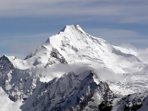 Although describing Huayna Potosi as “the easiest ‘6000er’ in the world” ignores its high-altitude challenge, there can be few mountains of this size that are more easily accessible: a jeep trip takes less than 2 hours to reach the base of the mountain from central La Paz. See from the Altiplano, the mountain is an imposing ice pyramid. The view changes from Zongo Pass, where it is possible to see the whole East Face, and the mountain becomes far more elongated and complicated.
| AGENDA *HPM3 | |
|
NORMAL R0UT |
EAST FACE |
|
PLACE |
ZONGO VALLEY |
|
DISTANCE FROM LA PAZ |
2 HOURS |
|
FIRST ASCENT |
RUDOLF DIENST AND O.LOHSE |
|
ALTITUDE DIFFERENCE |
1100M (3,608FT) |
|
DAYS OF ASCENT |
3 |
|
GRADE |
FR: AD EASY (45 º -50 º) |
ITINERARY
DAY 1
09:00 Depart from the office to the warehouse to collect mountain climbing equipment between 10:00 to 10:30 a.m. Exit the storehouse to Huayna Potosi. Lunch at the Lodge in the afternoon, then leave for the glacier where climbing practice takes place for 3 to 4 hours, after return to the shelter which offers a dinner and accommodation.
DAY 2
9:00 Breakfast, morning break.
12:00 . Lunch and leave for the base camp of Huayna Potosi. The first part is a walk over rock and the second part is a mixture of rock and snow depending on time, up to the High Camp where is the second shelter to 5.300 m.s.n.m. and it takes 3 to 4 hours to get there. Dinner and overnight stay.
DAY 3
01:00 It begins the ascent to the summit which is approximately six to seven hours of walking and climbing (6,088 m.s.n.m.) After visiting the summit back to the shelter II, and then shelter I. Lunch and return to La Paz in our private transport.
 photo
photo equipment
 map
map routes
 up
up
 map
mapCharquini 5350 m.s.n.m.
This mountain is situated 3 Kms. Away and towards the south-eastern direction of the Huayna Potosí Lodge. On route to the glacier there are a number interesting and beautiful lagoons.
The downward slope is not particularly difficult. Moreover, it’s possible to practice cross skiing. There are many ice caves where the glacier begins.
It’s a useful place to acclimatize and to practice some basic climbing techniques, especially for inexperienced climbers.
| AGENDA *HPM4 | |
|
NORMAL ROUTE |
NORTH EAST FACE |
|
PLACE |
PASO ZONGO ( 2KM.FROM REFUGIO H.P) |
|
DISTANCE FROM LA PAZ |
2 HOURS |
|
FIRST ASCENT |
|
|
ALTITUDE DIFFERENCE |
400 m |
|
DAYS OF ASCENT |
1 |
|
GRADE |
FR:AD EASY (45º-50º) |
ITINERARY
06:00 Depart from the office to storehouse to prove the equipment and heading to the base camp of RefugeHuaynaPotosi.
07:30 Refugio Huayna Potosi I, walk until Charquini, for practice climbing of 3 to 4 hours. Then we return to the Refuge, refreshment and return to La Paz.
photoequipmentmap routesup
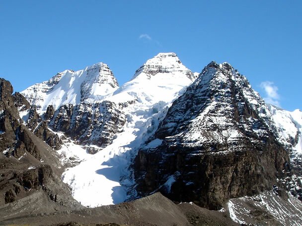
Pequeño Alpamayo 5370 m.s.n.m.
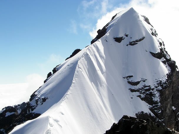 This peak is impressive, beautiful, and justifiably popular. From base camp, you can see only the top part of the summit, but the view of the mountain from Tarija is awesome. The pyramid of snow and rock looks much harder to climb than it is. The descent presents more problems than the ascent—either from crampons balling-up or from having to downclimb short ice sections.
| AGENDA *HPM5 | |
|
NORMAL ROUTE |
NORTH EAST FROM THE PEAK |
|
PLACE |
CONDORIRI |
|
DISTANCE FROM LA PAZ |
2 ½ TO 3 HOURS |
|
FIRST ASCENT |
IRENE AND KEITH WHITELOCK |
|
ALTITUDE DIFFERENCE |
250M (820FT) |
|
DAYS OF ASCENT |
3 |
|
GRADE |
FR:AD EASY (45º-50º) |
ITINERARY
DAY 1
09:00 Departure by transport from La Paz to Tuni Condoriri. Walk from 2 to 3 hours to the base camp of Condoriri (Laguna Chiarcota) with pack animals and guide. Camping in tents.
DAY 2
Pequeño Alpamayo Climbing return to base camp and camping in tents.
DAY 3
Return to Tuni, about 2 hours walking and return to the city of La Paz.
photoequipmentmap routesup
 map
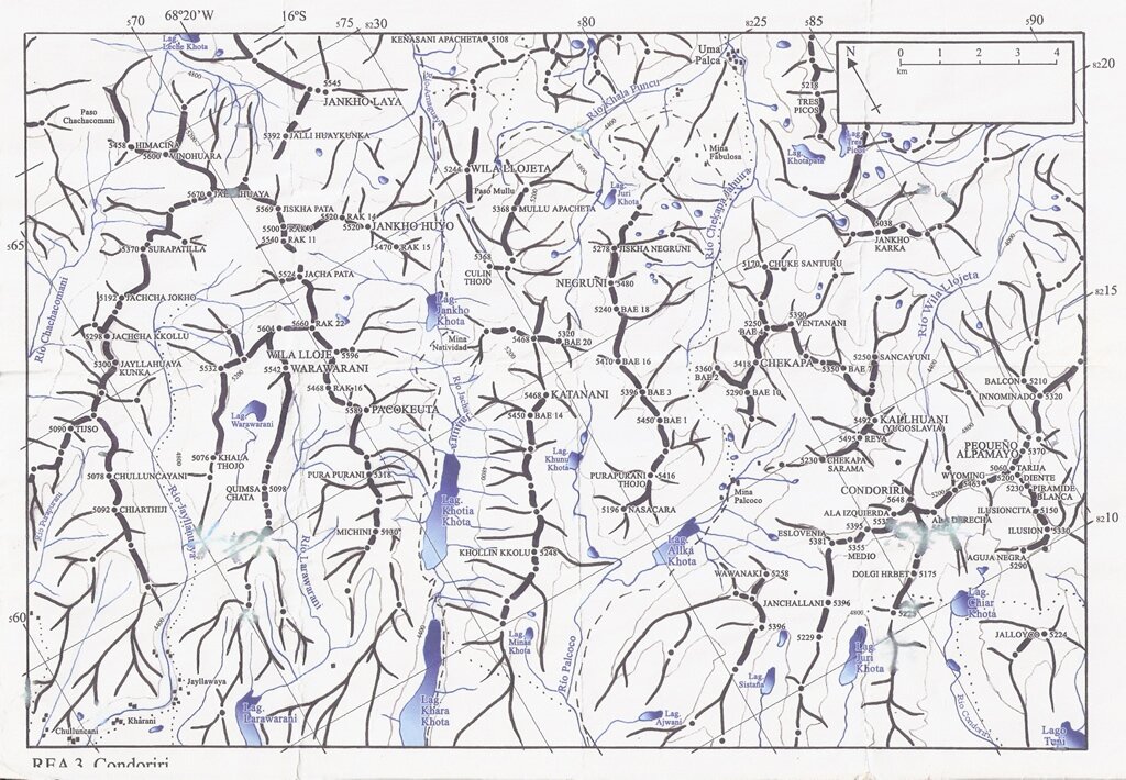
mapCondoriri 5648 m.s.n.m.
 Each peak is accessible within 1 day’s journey from base camp, which is idyllically situated on the shores of Laguna Chiar Khota (“Black lake”) with views of the striking Cabeza de Condor and its two wings. Hans Ertl desceibed his camp at Condoriri in 1953 as “truly fairylike”, Easy access from La Paz, pure snow face and ridge routes plus missed routes, ranging from easy to extreme, make Condoriri a delightful climbing playground.
| AGENDA *HPM6 | |
|
NORMAL ROUTE |
CONDOR HEAD |
|
PLACE |
CENTER OF CONDORIRI |
|
DISTANCE FROM LA PAZ |
2 ½ TO 3 HOURS |
|
FIRST ASCENT |
ANGELO GELMI,JOSE FERRARI,ALAIN MESILI |
|
ALTITUDE DIFFERENCE |
550M (1,804ft) |
|
DAYS OF ASCENT |
4 |
|
GRADE |
FR:D + (50º-60º) |
ITINERARY
DAY 1
09:00 Departure by transport from La Paz to Tuni Condoriri. Walk to the base camp Condoriri approximately 2 to 3 hours with pack animals and guide. Camping.
DAY 2
Small Climbing Alpamayo base camp and return to Camping.
Day 3
Climbing to the Head of the Condor and return to base camp. Camping. (Optional with the peak Illusion).
DAY 4
Return to Tuni, about 2 hours walking and return to the city of La Paz.
photoequipmentmap routesup
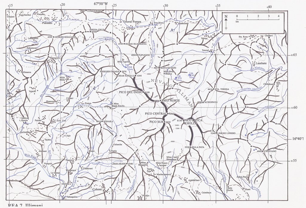
Illimani 6439 m.s.n.m.
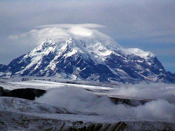 Illimani is the highest and southernmost peak in the Cordillera Real and dominates views from the capital city of La Paz. Hans Ertl, writing in Mountain World (1953), described Illimani as “one of the most beautiful and impressive groups of peaks in South America”. It is not so much a mountain as a massif—the glaciations measures 8 Km/5 m from one end to the other. From La Paz, the mountain appears to have three summits: the highest, Pico Sur, is to the right, but two other major summits are hidden from view, as well as a number of others. The west side is heavily glaciated, while the rarely climbed south and east sides’ present imposing ice gullies.
| AGENDA *HPM8 | |
|
NORMAL ROUTE |
WEST FACE |
|
PLACE |
SOUTHERN SECTION– REGION LA PAZ |
|
DISTANCE FROM LA PAZ |
4 HOURS |
|
FIRST ASCENT |
CHARLES WIENER, JOSÈ OCAMPO, I. BREMBLOW |
|
ALTITUDE DIFFERENCE |
1400m (4,592FT) |
|
DAYS OF ASCENT |
4 |
|
GRADE |
FR:PD (50º-60º) |
ITINERARY
DAY 1
09:00 Departure from La Paz to Pinaya in private transport, which takes 3 to 4 hours. Broken Bridge Walk of 3 to 4 hours with animals. Camping (4,500 m.s.n.m.)
DAY 2
Broken Bridge Walk up to Condors Nest (5,500 m.s.n.m.), takes about 6 hours with porters, camping. (High Camp)
DAY 3
From Condors Nest we ascend to the summit of Illimani South Peak (6,462 m.s.n.m.). from 6 to 8 hours of climbing. Return to Puente Roto. Camping
DAY 4
Descent to Puente Roto Pinaya, return to La Paz.
photoequipmentmap routesup
 map
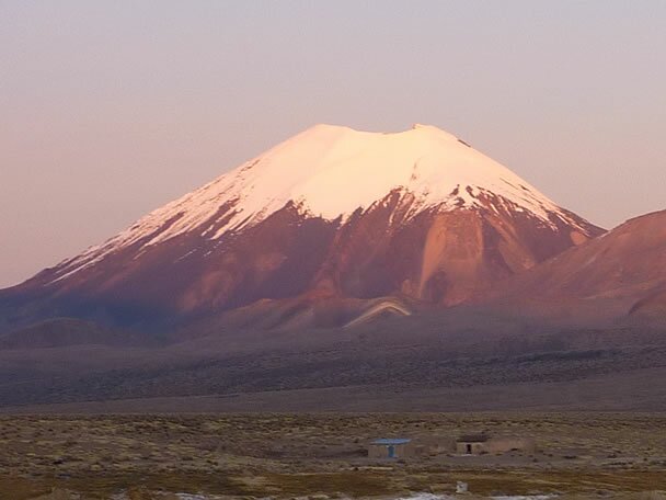
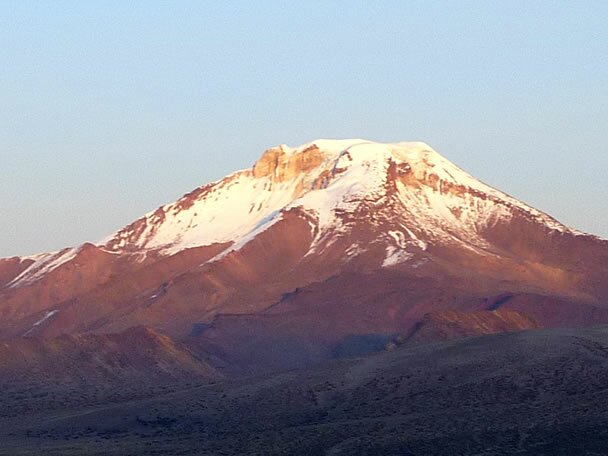
mapSajama 6549 m.s.n.m.
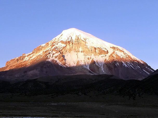 Bolivia’s highest mountain is 25 Km/16 miles from the border with Chile. The normal routes are long and easy, but there are plenty of opportunities for new hard routes, especially early in the season, following ice lines on the rocky west face. It is essential to be acclimatized before attempting Sajama.
| AGENDA *HPM9 | |
|
NORMAL ROUTE |
SOUHT EAST FACE |
|
PLACE |
CORDILLERA OCCIDENTAL |
|
DISTANCE FROM LA PAZ |
5 HOURS |
|
FIRST ASCENT |
WILFRID KULHM, JOESPH PREM |
|
ALTITUDE DIFFERENCE |
1380m (4,526ft) |
|
DAYS OF ASCENT |
4 |
|
GRADE |
FR: AD+ (50º-55º) |
ITINERARY
DAY 1
Departure from La Paz to the town of Sajama and walk three to four hours to base camp with mules. Camping.
DAY 2
Walk four to five hours from base camp to high camp 5.500 m.s.n.m. with porters. Camping.
DAY 3
Climbing to the summit 6549 m.s.n.m. and return to high camp. Camping.
DAY 4
Descent to base camp and return to La Paz.
photoequipmentmap routesup
 map
mapParinacota (Payachata Grande, Payachata Sur) 6330 m.s.n.m.
 The leftmost, cone-shaped, higher of The Twins. The slog up to the snow line is hard effort. The mountain is classically cone-shaped, all routes are pretty much the samen on Parinacota plod up until you reach the crter rim an find yourself standing on the edge of a 100 m/330 ft+drop.
| AGENDA *HPM11 | |
|
NORMAL ROUTE |
EAST FACE |
|
PLACE |
CORDILLERA OCCIDENTAL |
|
DISTANCE FROM LA PAZ |
5 HOURS |
|
FIRST ASCENT |
JOSEPH PREM, CARLOS TERAN |
|
ALTITUDE DIFFERENCE |
880 m (2,886 ft) |
|
DAYS OF ASCENT |
4 |
|
GRADE |
FR: F (40º-50º) |
Parinacota has volcanic slopes with aesthetics of perfect and smooth summit lines ascending toward the cone. Located on the border with Chile, it presents no major climbing difficulty, it is relatively easy with a height of 6330 m.s.n.m.
ITINERARY
DAY 1
La Paz in private Transport to Sajama. From the village of Sajama we walk about 8 hours to base camp at Parinacota. Camping.
DAY 2
Walk from 2 to 3 hours to high camp. Camping.
DAY 3
Ascent to the summit and descend to base camp. Camping.
DAY 4
Descend to Sajama Base Camp and return to La Paz.
photoequipmentmap routesup
Pomerata (Pomerape, Payachata Norte) 6222 m.s.n.m.
 Pomerata does not have such a classic shape as its neighbor, but it offers more challenging climbing. The routes are long, and if you are attempting some of the more technical lines, an early start is advisable. A compass is necessary to sort out your bearings for the descent.
| AGENDA *HPM12 | |
|
NORMAL ROUTE |
SOUTH WEST FACE |
|
PLACE |
CORDILLERA OCCIDENTAL |
|
DISTANCE FROM LA PAZ |
5 HOURS |
|
FIRST ASCENT |
EDMUNDO GACIA AND RENÉ ZALLÉS. |
|
ALTITUDE DIFFERENCE |
1100 m (3,608 ft ) |
|
DAYS OF ASCENT |
4 |
|
GRADO |
FR: AD (55º-60º) |
ITINERARY
DAY 1
Departure from La Paz to Sajama - Sajama Base Camp.
DAY 2
Ascent to high camp. Camping.
DAY 3
Ascent to the summit - down to base camp. Camping.
DAY 4
Return to La Paz.
photoequipmentmap routesup
Mururata 5868 m.s.n.m.
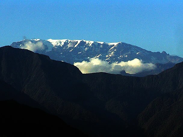 Mururata mountain is located to the left of Illimani. It presents no sharp peak, its summit is a great plain rather ideal for the mountain skyi.
| AGENDA *HPM13 | |
|
NORMAL ROUTE |
|
|
PLACE |
SOUTHERN SECTION– LA PAZ ZONA TRES RIOS |
|
DISTANCE FROM LA PAZ |
|
|
FIRST ASCENT |
VALENTINO PIZZOTT Y JOSE QUISPE |
|
ALTITUDE DIFFERENCE |
1100m (3,608ft) |
|
DAYS OF ASCENT |
3 |
|
GRADE |
FR: F EASY |
ITINERARY
DAY 1
09:00 Departure from La Paz to Choquecota in private transport. Walk from 5 to 6 hours to base camp with pack animals. Camping.
DAY 2
12:00 Breakfast.
01:00 Climbing to the summit, approximately 8 hours.
DAY 3
Return to base camp and return to La Paz.
photoequipmentmap routesup
 map
mapAncohuma 6427 m.s.n.m.
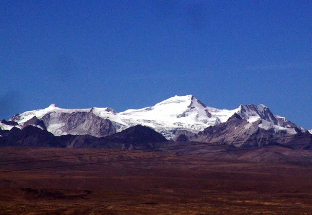 Generations of Bolivian and other cartographers have claimed that Ancohuma is the highest mountain in Bolivia and given it heights of up to 7,014 m/ 23,012 ft, which would make it the only mountain in the world over 7,000 / 23,000 ft outside the Himalayas. It is generally held that Aconcagua in Argentina is the highest mountain outside the Himalayas at 6,960 m/22,834 ft. However, it is true that Ancohuma is the highest peak of the Ancohuma-Illampu massif.
| AGENDA *HPM14 | |
|
NORMAL ROUTE |
SOUTH WEST FACE |
|
PLACE |
EAST FROM ANCOHUMA- SOUTH EAST SECTION |
|
DISTANCE FROM LA PAZ |
4 HOURS |
|
FIRST ASCENT |
R.DIENST Y A. SHULZE |
|
ALTITUDE DIFFERENCE |
960M (3,148 FT) |
|
DAYS OF ASCENT |
7 |
|
GRADE |
FR: D (40º-45º) |
ITINERARY
DAY 1
Departure from La Paz to Sorata. Rest in hostel.
DAY 2
Leave Sorata and ascend to Laguna Glacial (base camp) to 5100 m.s.n.m. Camping.
DAY 3
Ascent to high camp at 5600 m.s.n.m.Camping.
DAY 4
Climb to the summit 6427 m.s.n.m.Descend to the high camp. Camping.
DAY 5
Descent to the glacial lake base camp. Camping
DAY 6
Descent to the town of Sorata and rest.
DAY 7
Return to La Paz.
photoequipmentmap routesup
 map
mapIllampu 6368 m.s.n.m.
 Big high camp, and complicated, Illampu boasts the hardest normal route of any of the 6,000 m/ 20,000 ft peaks in Bolivia. This makes any climb on the mountain serious—there is no easy way off—and the hardest routes yet climbed in Bolivia have been done on the mountain.
| AGENDA *HPM15 | |
|
NORMAL ROUTE |
|
|
PLACE |
CORDILLERA REAL. NORTHWEST |
|
DISTANCE FROM LA PAZ |
4 HOURS |
|
FIRST ASCENT |
ERNESTO SANCHEZ. ALAIN MESILI |
|
ALTITUDE DIFFERENCE |
1200 m. (3.936 FT) |
|
DAYS OF ASCENT |
7 |
|
GRADE |
FR: AD+ 45º/60º/70º |
ITINERARY
DAY 1
08:00 Departure in private transport from La Paz to Sorata and rest at hotel.
DAY 2
09:00 Walk approximately 5 hours until Lakatia with pack animals. Camping.
DAY 3
09:00 Walk approximately 5 hours to Aguas Calientes Lakatia with pack animals. Camping.
DAY 4
09:00 Walk for about 7 hours from Aguas Calientes to High Camp (5500 m.s.n.m.) with porters. Camping
DAY 5
12:00 Breakfast.
01:00 Climb to the summit for sunrise and then descend to high camp. Camping.
DAY 6
09:00 Descend to high camp at Ancohuma. Camping.
DAY 7
Return to La Paz.
photoequipmentmap routesup
moutaineering | trekking | special | all terrain vehicles | mountain school | refugio | routes | home | conditions | logistics | faq | consults | about us | calendar | gallery | merchandise | map